I have finished a detailed map of the Egyptian Presidential Election final round results for the Nile Delta and major urban areas. The Supreme Presidential Electoral Commission has issued official results in at the Markaz (rural) and Qism (urban) level available in PDFs on their website, elections.eg. As we remember from Judge Farouk Sultan’s interminable speech on June 25 just before announcing the official election result, the SPEC made many adjustments to the unofficial counts released on June 18, the day after polls closed. However, these adjustments represent a very small fraction of one percent of the votes cast. The fact that the Muslim Brotherhood count from June 18 and the official state count were so close gives me confidence that, while votes may have been illegitimately influenced by actions outside the polling booth, the polls themselves were relatively fairly conducted. This means this body of data is the first reliable indication ever of Egyptians’ preferences over a very stark binary choice for the direction of the state: Islamism or “Feloul” (old-regime) revanchism. Obviously, many Egyptians went out to vote AGAINST either choice, but the geographical distribution of the result shows very strong regional tendencies, raising interesting questions about voters’ overall motives.
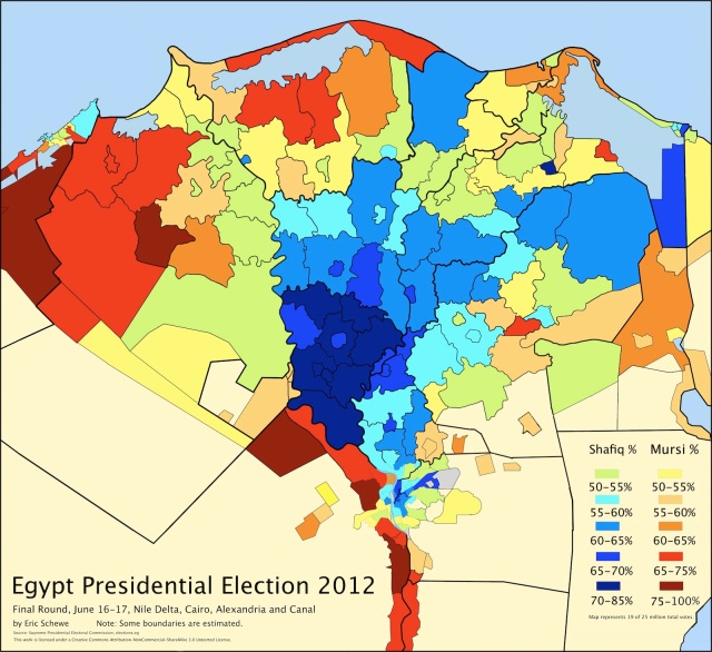 I have made some compromises to portray the massive amount of information on this map. This copy emphasizes the color patterns for quick reference, without place names.
Download the FULL SIZE MAP (6400 by 6400 pixels) with district number labels. The link is to a larger but still compressed preview on Google Drive. In the upper left corner, click “File” and choose “Download” to obtain the 3.4 MB file.
Then consult the FULL MAP DATA I compiled on a Google spreadsheet. It connects the number labels to the English and Arabic names of each district, but it also has all the votes, percentages, etc.
A brief note about the maps. The main borders are accurate to scale, but I have made some shortcuts and estimations in markaz and qism boundaries, especially for the smaller urban areas, so the map should not be considered official or error-free. I assembled the map by comparing several different sources. The official Governorate websites infrequently have geographically accurate maps of the qism and markaz divisions. I obtained the most reliable information from a series of government population density maps that I discovered used at different websites (here is an example). I also wanted the map only to show inhabited areas, so as a last step, I checked satellite images to create up-to-date boundaries for marshes, desert and satellite cities. As a quick reference: here are the major governorates and cities indicated on a simpler map.
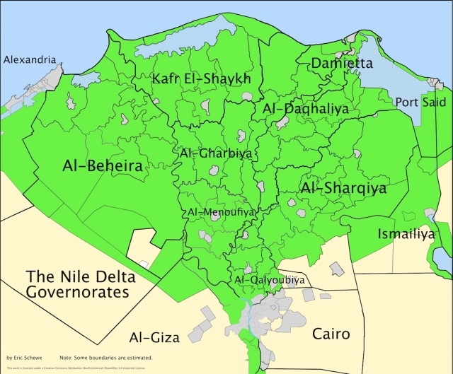 I chose to make a map with these dimensions because it fit the greatest population into the smallest area, allowing a map with significant numbers at a reasonable image resolution. Here is my original Mursi map of the full country at the governorate level. Of the 25 million votes cast in the election, 19 million were within the boundaries of this new map. Shafiq did much better within the area of this map than outside it. Of the votes on the map, Shafiq took 9.9 million and Mursi only 9 million. In Upper Egypt (south of Cairo) and the desert governorates, Mursi took 4 million votes and Shafiq only 2.4 million.
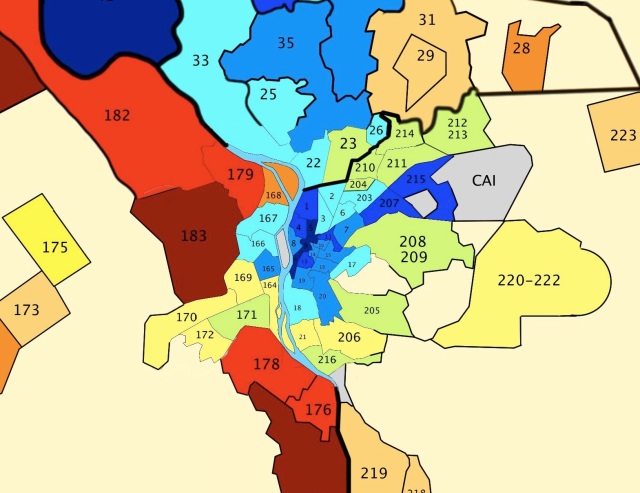 The map is an extension of my previous effort that focused on the core of Cairo Governorate. The patterns I mentioned in that post are just as plain here, especially with the satellite cities of Al-Shaykh Zayed and 6th of October in Giza (173-175), and “New Cairo” or Al-Tagammuʿ Al-Khamis (220-222) in view. Even though one assumes a strong class effect in the vote — the lower and working classes for Mursi and the middle and upper classes for Shafiq — those of all classes who continue to live in the core of the city (and secular-European culture oriented Heliopolis) voted overwhelmingly for Shafiq, while voters living in these suburbs, many of which are upscale, rarely went more than 55% for Shafiq and frequently preferred Mursi. As with the formerly exclusive Al-Maʿadi, many unplanned slums live side by side with wealthy new gated communities in the urban periphery, meaning the electoral districts may reflect a mix of socioeconomic classes. President Morsi lives in a McMansion in New Cairo.
The relation between class, space and voting preference seems a little more clear-cut in Alexandria. The original core of the city (193-196) slightly prefers Shafiq, but nowhere near as much as Cairo. The entire strand from downtown Alexandria to Muntazah (186-187), a high rent district with ocean views, voted far less for Mursi than anywhere inland, where he received 65% and higher support nearly everywhere.
Taking in the Delta as a whole, the most striking feature is the uniformity of support for Shafiq in Al-Menoufiya. Except for Shibin el-Kom (37) and Markaz al-Shuhada (ironic?, 43), and Sadat City (48), industrial development land on the west side of the Nile, Shafiq received higher than 70% of the vote everywhere in this governorate. He was only this popular outside Al-Menoufiya in Cairo and a small city, Al-Kurdi (76), in Al-Daqhaliya (I don’t know why he was so popular there, but here’s a story in Arabic about a bunch of ex-NDP parliamentarians having a party in Shafiq’s honor with pictures). This monolithic slab of dark blue tends to make me suspicious that the Shafiq voting machine not only used aggressive tactics in Al-Menoufiya, but uniquely aggressive tactics. This could have included corruption at the higher levels of the governorate executive bureaucracy. More likely, it was ex-NDP patronage channels that encourage voters to come out for immediate or deferred rewards. Let’s hope they took the immediate rewards.
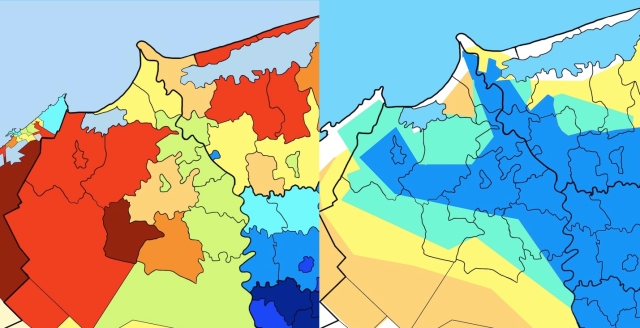
The second and more significant visual pattern on the map is the general contiguity between areas. There are concentric bands of similar voting behavior radiating out from Al-Menoufiya: 60-65% for Shafiq in southern Al-Gharbiya and Al-Daqhaliya, 55-60% in the rest of Al-Gharbiya, southern Al-Sharqiya and much of Al-Qalyoubiya. Shafiq support then drops off rapidly, with some exceptions. But this pattern is not merely geometric. I kept looking at this map and thinking I’d seen it somewhere before. I slowly realized that it looks very similar to historical maps of agricultural land reclamation. To confirm this hunch, I took my map template and laid out a simple land reclamation map with similar colors to the electoral map:
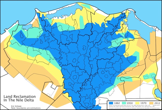 This map is an overlay of a few old maps and current satellite images showing the extent of cultivation in the delta from 1882 to the present. View the larger size here. Rich river delta soil has high agricultural potential, but deltas are naturally chaotic environments, prone to flooding and shifts in the course of tributaries that make rigorous irrigation a prerequisite to getting long term value out of them. The Nile historically received a huge flood in late summer because of rain patters in Sudan, Ethiopia, Uganda, etc. The rhythm of this flood promotes the growth of large marshes and shallow brackish lakes behind barrier islands at the coasts. Moreover, even small variations in topography can make raising enough water to feed areas outside the flood plain (in this case, the desert) difficult when there is an irregular supply of water. Through its long history, Egypt’s irrigation network has waxed and waned. Maintaining canals that filled with silt during the flood required a strong state bureaucracy to manage the huge labor requirement. In the 17th and 18th centuries, slackening Ottoman power in Egypt meant the irrigation bureaucracy was weak. The blue area on the map (1882) mostly reflects the natural flood plain with good drainage, which tapers down along the two branches of the Nile to Rosetta in the west and Damietta in the east.
The major public works project of Muhammad ʿAli Pasha’s reign as Governor of Egypt was the Mahmoudiya canal (completed 1820), built to bring fresh water to Alexandria and irrigate Al-Beheira. This land is indicated in the blue spur to the west on the map. His successors invested heavily in canals and dams to improve the flow of water during the early summer to promote cotton cash cropping. Muhammad ʿAli’s son, Saʿid, built (or properly, re-excavated) a fresh water canal (1863) to the east to supply the cities along the more famous Suez Canal; Saʿid’s successor Ismaʿil put his own name on it, and the city at the midpoint of the Suez Canal, when he became Khedive. This water was eventually used to irrigate large areas in the east (the green and yellow spur). When the British ran Egypt (1882-1923), they imposed a regime of fiscal austerity with almost all surplus state revenues committed to the improvement of public works to promote land investment and reclamation. The British finished the Nile Barrages (1891) at the fork of the Nile just north of Cairo and the first Aswan Dam (1902), which allowed an even higher water level in May and correspondingly higher cotton cultivation. But they also, less spectacularly, improved the system of drainage across the country. Irrigation is not as simple as dumping water on plants. There needs to be a constant flow of water, especially under hot conditions. Stagnant water will evaporate, leaving harmful salts and minerals on the soil. Like a house or a city, irrigated land requires two sets of canals, one for fresh and the other for used water.
Drainage projects also allowed land investors during the colonial period to start claiming large areas of new land from the marshes of Lakes Mariout and Idku in the west, Lake Burullus in the north and Lake Manzala in the east. Massive engineering works were fewer during the politically chaotic interwar period, but President Nasser (1954-1970) brought back land reclamation and its distribution to the small peasantry as one of the keystones of his economic and social policies, with the full power of the state to get the job done. The jewel in the crown, of course, is the High Aswan Dam, which took his entire administration to finish. It ended the seasonal flood altogether, allowing an even supply of water across the year, spreading perennial agriculture to most arable land in the country. Without the flood, draining the marshes also became much easier. In the years since, the state and land investors have pushed further into the desert of the southwest and southeast, with somewhat tenuous results. Anyone riding a bus from Cairo to Alexandria can observe the somewhat scorched-looking meager trees and crops growing just east of the desert highway and wonder how someone is profiting from that land.
So how does this bear on elections? Life, and the state, have not been as friendly to the peasants who have lived and worked on reclaimed land. Because of the large investment involved to make the land, the peasants who have moved to these places have mostly been tenants or wage laborers on private estates of the wealthy. When they have been given title to the land, like during the Nasser era, the land quality has not been great because of a lack of investment in drainage. As an example, Al-Beheira is a province mostly reclaimed in the past 200 years (in the comparison image below). The first land that Muhammad ʿAli created in this area he gave as huge plantations to members of his family. During the British occupation, large investment companies focused on reclaiming more land, and the existing royal lands were sold off to European investors and the Egyptian haute bourgeoisie to pay off the state debt. By 1945, only 26% of the land in Al-Beheira was owned by proprietors who owned 10 feddans (about 10 acres) or less, while the land owned by individuals or companies holding 100 feddans or more, i.e. pure rentiers, was 47% of the land. In Al-Menoufiya, by comparison, these figures were 64% (10 feddans or less) and 10% (100 feddans or more).
Despite the 1952 Land Reform Law, these patterns have remained firmly entrenched in these places to the present. The law outlawed personal holdings of more than 200 feddans of land, although many wealthy families got around this provision by distributing the deeds among elderly aunts, etc. More than 100,000 landless peasant families did receive small parcels of two to five feddans, but this was only a small proportion of the overall landless population. Others benefited from minimum wage and rent control rules. But the major winners were rich middling peasants (much more prevalent in Al-Menoufiya) who already owned land and acquired much more from the Pashas who sold off their land in fire sales, and milked the Nasserist cooperatives for cheap seed and fertilizer.
In the last 20 years, Mubarak quietly retired or canceled many of the reform laws. The Guardian covered this succinctly at the beginning of the revolution. Since that time, the news has been filled with landlords increasing rent threefold and even pre-1952 owners suing peasants who received title to their land under land reform to get their land back. In cases the peasants resist, they send in thugs to seal the deal.
While all of this doesn’t explain why a landless peasant would necessarily be a pious Muslim or want an Islamist government, it does explain why they would want to vote against an elitist ex-regime minister who curried favor with his landlord. The reclaimed land-Muslim Brotherhood pattern doesn’t hold everywhere. For example, in the South district of Port Said governorate (155), where the newest reclaimed land in the country is being rolled out of Lake Manzala in parallel strips, Shafiq took 66% (out of only 8500 votes).
This map provokes many more questions, so I encourage comments below. I have licensed the maps under a Creative Commons Attribution-NonCommercial-ShareAlike 3.0 Unported License. Please share!



Dear Sir,
First, thank you for sharing this. Living in Cairo as an expat, I began more or less the same work as an “hobbyist”, with the intention of getting my own view of the situation and developing an empty map at district level in order to have something available for other pools, and to try to establish sound relations between economic and social indicators and voting behaviour. I would be happy to have the opportunity to exchange with you, the job you did is terrific. Yesterday evening I worked on Alex area, it’s indeed very difficult to find any good map, I did my own. I guess we faced more or less the same issues,
Best regards, Pat
what are u exactly work on, cause this is my field of study “electoral geography”, i hope we can get acquainted
Eric,
I can’t believe how much effort you put into this mapping and analysis. I’m in awe.
I have a couple of questions:
1. Are these admin-3 boundaries (qism and markaz) or electoral constituencies? I guess they are admin-3 but I wonder how you got to extract the data (which I imagine were published by electoral constituency?).
2. Are these the updated demarcations after the admin changes that have been made in 2010?
I have been trying to create an open-source admin-3 boundaries dataset for open research, because as you know, the government doesn’t release it without a fight. And I was wondering if A. you are willing to share this dataset publicly, and if not, B. how do you recommend I start from scratch? Is it legal to digitize .jpeg maps like the Monoufeya example you mentioned? Do you know if there’s any official agency in Egypt where I can buy paper maps of the new demarcations and digitize them? (if legal). Do you know other ways that can be useful?
Thanks so much for your hard work!
Sawsan Gad
Co-founder | HarassMap.org
sawsan, hi, i’m a GIS analyst, and if u wanna the complete national data about administrative units, i got it from the CAPMAS in the form of a geodatabase
I really wonder the reason why you branded this specific blog post, “District Map
of the Presidential Election in Lower Egypt:
An Environmental History | Eric Schewe”. In any event .
I actually loved the post!I appreciate it,Jaunita
Eric,
My name is Emily Samuelson and I am currently doing research in the political science department at the University of Michigan. I’m very interested in finding out the smallest and most detailed units for which election data was tallied for Egypt’s 2012 election. Your spreadsheet in this post is the most detailed I’ve found so far, and you reference that on elections.eg the Supreme Presidential Electoral Commission has the results at the Markaz and Qism levels. I’ve searched the website and have not been able to find these results, though that may just be because I don’t read or speak Arabic.
Is there any way you have the source data from elections.eg that you would be willing to share with either myself or my professor? Or any source data from which you received the information on your spreadsheet regarding the election results, for that matter. If you’re willing to share such information, please let me know and I will Direct Message you my e-mail address via Twitter so we can get in touch in a less public setting.
Thank you so much,
Emily
Eric, these maps are fantastic and its very evident the amount of effort you spent! Do you have a shapefile for electoral districts you’d be willing to share? Thanks!